Thursday, 25 April 2013

Host update: Community Action Suffolk E-bikes


The community development agency Community Action Suffolk is keen to promote sustainable travel as part of their responsibility in reducing the negative impact on the environment. They were one of the very first Bike Aid hosts when they were previously known as Suffolk ACRE. Now two electric cycles, named Bert and Ernie, have become available for use by staff and tenants in their Ipswich offices at Brightspace for short range travel within the Ipswich area. They also provide safety equipment such as high visibility vests and cycle helmets as well as a security lock and lights.

A journey into the town or to Suffolk County Council’s Endeavour House now takes just a few minutes and there’s no need to hunt about for a parking space at the other end either. 

The bikes have been part funded by the Low Carbon Champions Project, Suffolk County Council and the European Regional Development Fund.

With two identical bikes, will the temptation for users heading to the same meeting to race them be resisted?


SCCP Bike Ride & Halesworth Food and Drink Fair


This is a local event in our home town so it needs a plug: 9.30 am, 23rd June 2013. Starts and ends from World Land Trust, Bridge Street, Halesworth IP19 8AB.


On the same day and same place is the Halesworth Food and Drink Fair being organised by Jo Crampton of Banyan Fairtrade. If interested in having a stall here, please contact Jo as soon as possible on 01986 872345 or jo@myfairtrade.co.uk and twitter: @ehippies


Wednesday, 24 April 2013

Get Britain Cycling


The All Party Parliamentary Cycling Group report 'Get Britain Cycling' has been released today. You can read the full report at 


We see that £18 million invested on 'cycling towns' got a £64 million return in benefits by same appraisal method used for highways.

In a long list of recommendations, it has:


5 Integration with public transport
5.1 Cycling should be promoted in conjunction with public transport as a 
healthy and sustainable door-to-door option for longer-distance journeys. 
This can be done through:
• Good access to, from and within stations and interchanges
• Secure, sheltered and accessible cycle parking;
• Cycle centres (offering cycle hire, repair and storage facilities) at larger 
stations and interchanges.

• Providing cycle carriage space on new and refurbished trains and trams 
(also on some buses, e.g. for more lightly used routes serving areas which 
are popular for recreational cycling activity, including mountain biking).

Naturally, Suffolk Bike Aid posits a far greater return on investment if authorities could have the imagination to adopt and promote our scheme.

Tuesday, 23 April 2013

Host Profile: Bankside B&B


Bankside B&B is an elegant non-smoking 4 star boutique bed and breakfast situated in the Suffolk hamlet of Uggeshall, just minutes from Southwold on the Heritage Coast. There is ample parking and secure storage for bikes and wi-fi throughout.

Breakfasts are served with local produce and home-made bread and preserves.

Hosts Elaine and Tony have made a puncture kit, tools and pump available for guests and passing cyclists who might need them. Please just ring the bell and ask.

Directions:

Uggeshall and Bankside B&B is situated just north of Henham Park. From the A12, take the B1126 Wangford Rd away from Wangford toward Stoven and turn left just before St Mary's Church and Bankside B&B is situated about half a mile on the right.

On the A145 London Road midway between Brampton and Blythburgh, take Stoven Road signed towards Wangford and Uggeshall and then the first turning on the right. Bankside B&B will be on your left after some houses.

Bankside B&B, The Hills, Uggeshall, Nr Southwold, Suffolk NR34 8EN
Tel: 01502 578047 Mobile: 0798 559 2543

Email: elaine@banksidebandb.co.uk


www.banksidebandb.co.uk


BedandBreakfast.gif SilverAward.gif BreakfastAward.gif food_hygiene.jpeg


Sunday, 7 April 2013

Host Profile: Gypsy Hollow B&B & Teas

If you fancy kipping next to nature in a gypsy wagon in the grounds of a Grade II* listed Suffolk farmhouse, then this is a B&B for you. 

Then wake up to hearty breakfasts of their own Gloucester Old Spot/Berkshire pork and fresh free-range eggs. You can cook their farm produce yourself on the open fire or in the kitchen area and afternoon tea cream cakes are available for your delectation.

Along with a spa to soak away the strains of a day in the saddle, what could be missing? 

Absolutely nothing now that it has joined Suffolk Bike Aid so passing cyclists can stop by to make running repairs if need be as well as get afternoon cakes and teas.

Proprietors Philip and Clair Westwood-Dreamer are located deep in the north Suffolk countryside (not far from the Norfolk border), roughly between the market towns of Halesworth and Bungay, yet only six miles from the A12. The can even pick up guests in their horse and carriage from Brampton rail station.

Directions From Halesworth


Take the A144 Norwich Road north for about 2 miles, then turn right onto Nollers Road and then left onto Butts Road.

From Bungay

Take the A144 south from Bungay for about 5 milles, then turn left onto Hog Lane, then right onto Butts Lane.
Gypsy Hollow B&B
Valley Farm
Butts Road
Westhall
Suffolk
IP19 8RN

Tel: 01986 780995
Mob: 07884 165445

52.39359, 1.51796

Source of cycling symbols

Bike Aid has scoured the internet for a source of official UK cycling symbols but couldn't find any.

But we did find a government handbook on cycle lane markings which will download as a PDF which enable you to enlarge and 'grab' the items to whatever scale you want. We did that with the cycle parking logo below. It seems sufficient for our purpose so we thought we'd share this tip.


Saturday, 6 April 2013

Vancouver bike repair station outrage

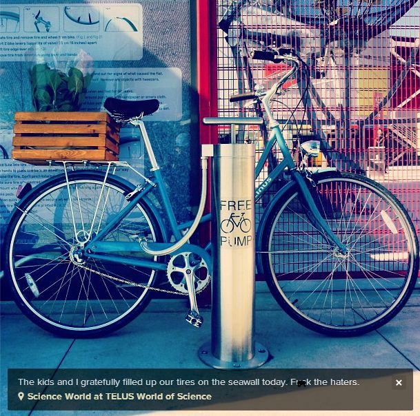
Vancouver's CityStudio BikeLab recently introduced the first publicly accessible bike repair stations to the streets of Vancouver. There are now two stands with tools and air pumps where cyclists will be able to repair simple mechanical problems.


This project is part of Vancouver's Greenest City 2020 Action Plan to encourage sustainable transportation.


Instagram of new pump posted by cbruntlett 

In partnership with the City of Vancouver and the Vancouver South Lions Club, this project is piloting two stations; one located in the Woodwards Atrium on the West Hastings entrance and another at Science World.


On Saturday, April 6th, the bike repair first station was unveiled to evaluate the possibility of developing another eight stations in the future.


However, despite Canada's reputation for affability, greenness and hippy values, the installation of two $3000 bicycle pumps has sparked outrage in media editorials.


The pumps were recently installed at Hawks Ave. and Union St. (on the Adanac bike route) and at Science World, near the convergence of the Seaside, Adanac, Ontario, and Central Valley Greenway bike routes. The pumps fit both Schrader and Presta valve types, and have been built to resist the elements. It’s been reported that the two pumps cost a total of $6,000

However, it wasn’t until last week when Scout Magazine and then the Vancouver Courier ran a story that things started heating up. Both The Province’s editorial board and CTV went trolling, and Yahoo! Canada News piled on for good measure. The Province ran an anonymous editorial that was nothing short of an anti-cycling diatribe and then CTV devoted 3 minutes at the top of their 5pm newscast to outrage over this expenditure

Perhaps the no-cost model of Suffolk Bike Aid would be more suitable here?


Monday, 1 April 2013

Cycling Embassy of Great Britain


The CEGB reckons that cycling should be the simplest, easiest and most convenient way to get around in most places in the UK and yet the reality is that it's not – the roads are busy and feel unsafe or unpleasant to ride on and what cycle paths there are seem to take the long way round, or run out just when you need them most.
We intend to act as a conduit for best practice around the World and get standards, as opposed to guidelines, implemented to create cycle infrastructure that we can all be proud of and that people will use.
We feel that this has to be addressed as a matter of urgency as badly designed and implemented infrastructure is continuing to be built at council taxpayers’ expense whether people like it or not.
 The Dutch and the Danes have demonstrated that it is easy to provide safe, attractive and efficient routes for cycling, away from fast traffic, which anybody and everybody – men and women, old and young, and rich and poor – want to use. 

The Cycling Embassy of Great Britain want to see an end to cyclists being pushed to the margins; they want to see a network of direct, well-designed, separated cycle routes that are safe even for young children to use. 

Manifesto & Mission Statement

Cyling Research Library

Sat Nav POI


With GPS satellite navigation technology commonplace in handheld devices and smart phones, if you provide services to cyclists it's probably worth the trouble to ensure that the master sat-nav Point Of Interest (POI) databases have your business in their listings. It's essential too that their maps accurately record local cycling infrastructure such as bike lanes or cycle paths. 


You can do this by checking the information held by Navteq, the main publisher of sat-nav databases. Unfortunately there isn't yet an official Bike Aid POI category but we're working on that.

Browse to http://mapreporter.navteq.com

Use the search box to find the place you want to report on or click-and-drag the map.

On the left of the web page are 4 main categories:

· Point of Interest. Here you can record or make changes to a shop, business, or other Point of Interest (POI). You can promote your community by listing local businesses as people often use their sat-nav as a 'Yellow Pages'.

· Address Marker/Location. Make changes to the location of a house or building.

· Road or Road Feature. Here you can add, edit or remove roads and road features such as signs, one-ways, or restrictions.

· Other not listed.

But if you right-click on a road itself, a dialogue box pops up:

· Edit details of this road

· Exit/Roundabout is new

· Turn restrictions have changed

· Signs are different

· Other categories

Click ‘edit details of this road’ and you will get a choice of:

· Edit Road Segment Details

· Data is correct, I want to report something else

If you click 'road segment' you can report any one-way restrictions, change the class of road, note any vehicle restrictions, the type of road surface and describe the house numbering. Quite often this data will be blank and so you will be providing a useful service to complete it.

Navteq classifies roads in their database as Class 1, 2, 3, 4. This corresponds to A, B, C, D roads. In the UK, only A and B are officially designated on signage although Highways Department will refer internally to C and D and Unclassified roads too.

If you click 'something else' you can add advice about road width restrictions or errors on the map that are not reportable elsewhere.

You can also attach photos of any errors or issues.

You can only report geographic information that can reasonably be reflected in a digital map. Therefore it is probably not much use to report “this road has a problem with speeding…” while reporting “the road is only eight feet wide at this point…” is more useful to the digital mapmakers.


Some GPS devices use data from another company Tele Atlas. You can enter less geographic information on their website but this database is more detailed in POI categories. http://mapinsight.teleatlas.com/mapfeedback/index.php

To research or record local features, or if you want to use maps without paying a hefty copyright fee, you can contribute to the OSM, a global ‘wiki’ map http://www.openstreetmap.org/ where you can record features of interest.


The UK Ordnance Survey gets its POI data from a company called Point X which the OS owns in partnership with Landmark Information Group. Point X doesn't indicate on its website how to correct or submit data but we have asked them and when they tell us we'll post it here. Landmark claims to be an unrivaled source of large scale current and historic digital maps together with high quality environmental risk and planning information.


PointX is a joint venture company established to provide the most comprehensive range of points of interest data in Great Britain. They have over 600 classifications ranging from airports to amusement parks, hospitals to hotels, petrol stations to pubs and restaurants to railway stations. Customers for this data are central government, the emergency services, local authorities and companies developing location-based services.

Point X says it has over 170 data suppliers including Market Locations (who replaced Thomson Directories), Department for Transport, Transport for London, Police, Fire and Ambulance Authorities, Education Authorities, Royal Mail, Visit Britain, LINK Interchange Network, The Court Service, UK Payphone Directory, Little Chef, National Trust for Scotland and the National Association of Citizens Advice Bureaux.

The Point X POI data is used for drawing the Traveline journey maps, in local government 'health checks' and by location pointing services such as finding your nearest swimming pool or ATM. It seems there has been some significant wrangling over merging this data with the 29 million entries of the seperate Postal Address File maintained by the Royal Mail, so these are not combined as yet though the postcode boundaries have been released to the Ordnance Survey.

I wonder how many POI errors that people familiar with Halesworth, Suffolk can find on this map Traveline served on 31/3/13. The public convenience #4 has been closed for a decade, public convenience #2 is non existent, but if it means those that were at the swimming pool, they were demolished in September 2010.